M.-A. Dubois1, L. H. Emmons2, L. Cournac3, P. Chatelet4, N. C. A. Pitman5, V. Vilca5, & L.-F. del Aguila6
1CEA Saclay, DSM/DRECAM/Service de Physique de l ’Etat Condensé, L ’Orme des Merisiers, 91191 Gif sur Yvette, France
2Department of Zoology NHB 390 MRC 108, Smithsonian Institution, P.O.Box 37012,Washington, DC 20013-7012 USA
3CEA Cadarache, DSV/DEVM/Laboratoire d ’Ecophysiologie de la Photosynthèse, 13108 Saint Paul Lez Durance Cedex, France
4CNRS/URA 1183,Muséum National d ’Histoire Naturelle,
4 avenue du Petit Château,91800 Brunoy, France
5Asociación para la Conservación de la Cuenca Amazonía,
Calle Cuzco 499, Puerto Maldonado, Madre de Dios, Perú
6Fundación Amigos de la Naturaleza, Santa Cruz de la Sierra, Bolivia

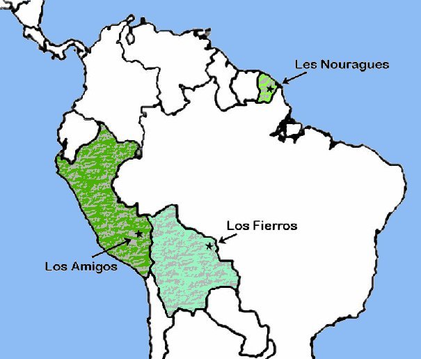
A team of scientists of the CEA (DSM and DSV), CNRS, Smithsonian Institute, and Peruvian and Bolivian research stations, recently published [1] a monthly follow-up over several years of the leaf-area index (LAI) in three stations distributed on a climatic gradient of South America, in French Guiana, Peru and Bolivia.
As expected, the method confirms that the seasonal variation is minimum close to the climatic equator (Guyana), and increases away from this line (Peru and especially Bolivia). It brings however, a surprising new and well marked result in the three studied sites: the leaf cover is maximum at the beginning of the dry season, and minimum during the rainy season. This result can be understood with the argument that the surface devoted to photosynthesis tends to be as high as possible when the solar radiation is maximum, but goes against the usual intuitions of the ecologists.
This finding has been just corroborated by a publication estimating the leaf area index by indirect methods [2] based on satellite data covering a large part of the Amazonian basin.

The initial publication presents direct, ground-based measurements of the leaf area index. Whoever knows the tropical forest will appreciate the quantity of work and the quality of international collaborations needed for a monthly follow-up in natural sites over several years and in three Amazonian countries … Ground data were taken by using a method and an instrument developed in a DSM-DSV collaboration with CNRS [3].
The leaf area index being a good indicator of the water and carbon exchanges with the atmosphere, climate models – in particular those developed at the CEA by the LSCE – will have to take this result into account.
[1] Seasonal change in leaf area index at three sites along a south American latitudinal gradient,
L. H. Emmons, P. Chatelet, L. Cournac, N. C. A. Pitman, V. Vilca, L.-F. del Aguila & M.-A. Dubois,
ECOTROPICA 12 (2006) 87
[2] Large seasonal swings in leaf area of Amazon rainforests,
R.B. Myneni et al.,
Proc. Natl. Acad. Sci. U S A., 104(12) (2007) 4820.
[3] Fast determination of light availability and leaf area index in tropical forests, L. Cournac, M.-A. Dubois, J. Chave & B. Riéra,
J. Trop. Ecol. 18 (2002) 295–302.
Cette méthode a été récompensée par un Prix de l’Innovation Technologique par la Direction des Sciences de la Matière du CEA.


